Gradient profile and mileages
Contents
Gradient Profile
The gradient profile of the SVR between Kidderminster and Bridgnorth is shown below. The diagram, which is reproduced from the SVR Visitor Guide Eighth Edition (2001), is based on official GWR documents.

The profile shows the average gradient in each section (the vertical scale is exaggerated), thus on leaving Kidderminster the line initially goes downhill with a gradient of 1 in 112. ‘L’ indicates level. According to the GWR gradient profiles, the steepest gradient on both the orignal Severn Valley Railway and the Loop line did not exceed an average of 1 in 100 in any section. The horizontal scale includes the mileages (see below).
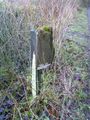
Gradient posts showing changes in gradient can be seen at the lineside. The design varies, but generally follows the principle of this prominent example near Northwood Halt.
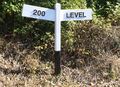
Gradient post

Mileages
The location of stations, bridges and other structures on the railway network are measured from a datum point (normally a major terminus). For the majority of the railways associated with the SVR the datum point was London Paddington (the exact zero point being the Paddington Suburban Tunnel boundary with the Metropolitan Railway). The individual routes used to reach those locations are identified by Engineer's Line References (ELRs).
The maps of the SVR shown below have been annotated with mileages taken from the relevant ELRs. All figures are shown in miles and chains (one chain is equal to 22 yards or 1/80th of a mile).
Oxford Worcester and Wolverhampton Line (OWW)
The ELR for the OWW began at Wolvercote Junction near Oxford (66 miles 32 chains from Paddington via Didcot). It ended at Priestfield Junction (140 miles 23 chains) near Wolverhampton. The section most relevant to the SVR is shown below.
|
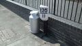
135.46 |
The SVR's Kidderminster Town station is measured as 135 miles 40 chains (exactly 135½ miles) from London. A milepost showing this distance is included in the gallery below.
Severn Valley Branch (SVB)
The ELR for the SVB began in the south at Hartlebury Junction and ended at the junction with the Shrewsbury and Hereford Line (SHL) near Sutton Bridge Junction. Shrewsbury lay 62 chains north of this junction; however Shrewsbury was used as the datum point for the SHL. Thus the junction for the Wellington line, which came between the two is measured as 11 chains from Shrewsbury rather than a distance from Paddington. Similarly Woofferton is measured as 32 miles 11 chains from Shrewsbury.
|
171.59 |
Bewdley to Kidderminster Curve (BYK)
The Loop between Kidderminster and Bewdley does not lie on a direct route from London Paddington. Distances to places on the Loop as set out in the Engineer's Line References were therefore measured on the basis that you would proceed towards Kidderminster and after passing Kidderminster Junction at 135 miles 9 chains, reach a reversal point 12 chains further on. Returning over the 12 chains to the Junction on the loop line (now 135 miles 33 chains), mileages are measured until Bewdley South Junction is reached at 138 miles 21 chains. However Bewdley South Junction was only 137 miles 12 chains via the direct route from Hartlebury; this lower figure becomes the base mileage for measuring distances onwards towards Bridgnorth and Tenbury. This accounts for the change in mileage at Bewdley South Junction in the profile above.
|
135.21 |
Early OS maps show the locations of mileposts on the loop line which do not accord with this method of calculation. Mileposts appear just east of Rifle Range Halt (see map below), just west of Stourport Road Bridge (the location of Foley Park Halt), and just south of Kidderminster Junction (see map below). This discrepancy could be accounted for if the earlier mileages were instead based on a reversal at Bewdley and then travelling towards Kidderminster, ie:
137.12 Bewdley South Junction SVB
137.15 Reversal point (assumed)
137.18 Bewdley South Junction BYK
137.76 Rifle Range Halt (placing milepost 138 just to the east)
139.07 Foley Park Halt (placing milepost 139 just to the west)
140.06 Kidderminster Junction BYK (placing milepost 140 just to the south)
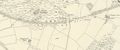
Milepost near the site of Rifle Range Halt

Mileposts
Early railway fares were set by distance, therefore it was necessary for railway companies to provide their passengers with a means of determining the distance travelled. The Railways Clauses Consolidation Act 1845 Section 94 stated "The company shall cause the length of the railway to be measured, and milestones, posts, or other conspicuous objects to be set up and maintained along the whole line thereof, at the distance of one quarter of a mile from each other, with numbers or marks inscribed thereon denoting such distances.[1]
Mileposts showing the distance from London Paddington, as measured above, can be seen at the lineside. In the second example shown, the distance just south of Arley Station is 140¾ miles (the vertical bars below the number show the number of quarter miles). One milepost is situated at the foot of Highley Signal Box, showing that it is exactly 143¼ miles from Paddington.
Mile post at Kidderminster
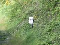
Mile post near Arley
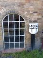
Mile post at Highley Signal box


The locations of the principal mileposts were often shown on early Ordnance Survey maps, such as this example from 1903 showing the presence of mileposts (MP) at Kidderminster Junction on both branches of the junction.
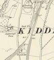
1903 OS map of Kidderminster Junction

Although the mileposts seen today were re-created in the modern era, they closely follow the historical design. The remains of this original milepost can still be seen next to the trackbed between Ironbridge and Buildwas.
Remains of an original milepost

Mileage oddities
In addition to the 'discontinuity' in the mileage at Bewdley South Junction referred to above, the present day SVR being situated on three different ELRs gives rise to some other apparent oddities. Leaving Kidderminster, the mileage initially decreases as you pass the first milepost by the carriage shed but then increases again as you continue (due to setting off towards London but then curving away from it). Reaching Kidderminster Junction, this is two different distances from London, depending on whether you are on the OWW line or the Severn Valley Branch (due to the latter being approached by the reversal point). Finally, on Safari Park Curve you pass milepost 137¾, and a short time later you enter Bewdley Station passing another milepost 137¾ (the former being reached via the Loop and the latter direct via Hartlebury.
See also
References
- ↑ Railways Clauses Consolidation Act 1845 Retrieved 23 May 2016