Variant spellings of SVR station names
Although the railways and Ordnance Survey helped to standardise the names and spelling of towns in Britain in the mid 19th century, many early maps and timetables show variations. Some of the stations on the Severn Valley and Tenbury branches were also renamed for various reasons.
Bridgnorth

Perhaps the most common misspelling in modern times, 'Bridgenorth' appears on several early plans for the SVR. It also appeared in the title of two unsuccessful proposals for railways linking Wolverhampton and Bridgnorth, the "Wolverhampton & Bridgenorth Railway" of 1860 and the "South Staffordshire & Central Wales Railway Dudley & Bridgenorth" of 1861.
Stourport
The Civil Parish of Stourport was renamed Stourport-on-Severn in 1934. Stourport station was similarly renamed in the same year.
Arley
At the opening of the SVR, Arley station and the neighbouring village lay in Staffordshire, with the area being transferred to Worcestershire in 1895. The village, which is mainly on the opposite bank of the River Severn from the railway, is officially Upper Arley.[1] It appears as such on most old Ordnance Survey maps, although some early maps named it Over Arley. However the use of the abbreviated form "Arley" appears long established. The manor house was known as Arley Hall and latterly Arley Castle until being demolished circa 1960,[2] while Arley Arboretum remains a popular attraction. Edwardian era postcards were also captioned "Arley"[3].
The area on the station side of the river is sometimes informally referred to as "Lower Arley", although there is no evidence from maps to support this. Lower Arley was an alternative name for Areley Kings near Stourport[4].
Richard Price Williams' 1872 Railway Map, which was probably based on an earlier diocesan map, is marked Upper Areley and Areley Hall.[5]
Highley
Highley Station is actually located in the small hamlet of Stanley, around ½ mile from the village of Highley itself, although the majority of its business originated from the village and its colliery. The 1866 working timetable and Bradshaw's Guide both give the name as "Higley", a spelling also seen on some older maps.
Hampton Loade

Hampton Loade station is actually located in Hampton on the west bank of the River Severn, with the main part of Hampton Loade village being on the east bank. The village was also historically known as Hampton's Loade.[4]
The station was originally named Hampton as shown in the opening timetable. However within a month it had adopted the name Hampton Loade which it has retained ever since.[6] A station at Hampton in London opened in 1864[7] and the name change may have been made to avoid potential confusion.
19th century OS maps include a number of other variant spellings. Maps surveyed in the 1880s still showed the station as "Hampton", with the hamlets on each bank being "Hempton" and "Hamptonload" as illustrated. The latter has also appeared as Hampton Lode (1876/1887) and Hampton Load in 1855.
The 1876 working timetable still gave the name as "Hampton", while Bradshaw's Guide used "Hampton Lode" up until 1877. "Hampton Lode" also appears on 'Bartholomew's Railway Map of the British Isles' of 1927.[8] John Randall's 'Handbook to the Severn Valley Railway' of 1863 gave the name as "Hampton's Loade".
Coalport
The town of Coalport was served by two stations. Coalport on the Severn Valley Branch was located on the west bank of the River Severn. On the other bank and directly opposite, Coalport East formed the terminus of the LNWR (later LMS) Coalport Branch Line which ran from Hadley Junction near Oakengates on the Stafford to Shrewsbury Line.
R.V.J. Butt's "The Directory of Railway Stations"[9] is commonly cited on Wikipedia and elsewhere as an authoritative work on station names.[note 1] Butt refers to the GWR station being renamed "Coalport West" during the BR era. This change may have been made for internal or administrative reasons, but the name "Coalport" continued to appear until closure in Engineer's Line References, BR Working Timetables, on the platform running in boards and even on the 1963 BR notice of closure of the line.
Ironbridge and Broseley

The station at Ironbridge was probably used more by the people of Broseley, located about ½ mile away on the same side of the River Severn, and the site of tile and clay pipe making industries. Ironbridge town itself is on the north bank and crossing the bridge required payment of a toll until 1950, a fact that undoubtedly discouraged passengers from Ironbridge using the station.[10]
Although the bridge from which it takes its name is referred to as "The Iron Bridge", the town itself is usually written as a single word. The station was originally named Ironbridge and Broseley at opening. However on 9 November 1895 the name of the station was changed to 'Iron Bridge and Broseley' on the recommendation of the General Manager.[11] The reason for his recommendation is unclear. The signal box name plate accordingly read "IRON BRIDGE & BROSELEY SIGNAL BOX", although strangely the platform running in board was lettered "IRON-BRIDGE AND BROSELEY.[10]
Different series of Ordnance Survey maps have shown at least three variants of the name over time, although rarely 'Iron Bridge'. For example:
- 1 inch series: Ironbridge (1899), Iron-bridge (1946, 1956, 1969), Iron Bridge (1947)
- 6 inch series: Ironbridge (1884), Iron-bridge (1903, 1928, 1948)
Tenbury
Tenbury station on the Wyre Forest Line was renamed Tenbury Wells on 4 November 1912 as part of the Worcestershire town's aspiration to achieve spa town status.[12] The station itself was on the opposite bank of the River Teme in the Shropshire parish of Burford.
Other
- Knowlesands is marked on modern maps as Knowle Sands, and on the 1855 plan as Knoll Sands.
- Northwood Halt is at North Wood.
- Foley Park Halt. A 1904 letter from the GWR to the Board of Trade requesting approval for a new halt at Foley Park is accompanied by a plan headed "Foley Park Motor Halte".[13]
Gallery
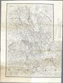
1855 map showing "Bridgenorth", "Hampton Load", "Higley" and "Knoll Sands"

See also
Notes
- ↑ Developing this Wiki has highlighted several apparent errors in Butt's 'authoritative' book. He states that Wyre Forest opened with the rest of the Tenbury Branch on 1 August 1864; Beddoes & Smith (1995) and Mitchell and Smith (2007) confirm it was not until 1 June 1869. He also states that Alveley Colliery Sidings "opened after 1915" and was then "renamed Alveley Colliery Halt". Alveley Sidings opened in 1939 at what is now Country Park Halt, while Alveley Halt was a short distance away and did not open until 1944.
References
- ↑ Upper Arley on Wikipedia
- ↑ Arley Castle on Dicamillo
- ↑ Geens (1985), various illustrations
- ↑ 4.0 4.1 Handbook to the Severn Valley Railway, by J. Randall 1863
- ↑ Richard Price Williams map on Timetable World
- ↑ Marshall (1989), p101
- ↑ Hampton Railway Station on Wikipedia
- ↑ timetableworld.com
- ↑ The Directory of Railway Stations: details every public and private passenger station, halt, platform and stopping place, past and present (1st ed.) Butt, R. V. J. (1995), Sparkford: Patrick Stephens Ltd. ISBN 978-1-85260-508-7
- ↑ 10.0 10.1 Vanns (1998/2013) pp. 38-40.
- ↑ Marshall (1989) p. 100.
- ↑ Beddoes & Smith (1995) p. 81.
- ↑ Documents held by Shropshire Archives