

| Towards Hartlebury and Kidderminster | Towards Shrewsbury |
|---|---|
| Bridgnorth (4¼ miles) | Coalport (2½ miles) |
Linley Station was located 22½ miles from Hartlebury and 18¼ miles from Shrewsbury. It was the first station north of Bridgnorth, and had a single platform with no passing loop.
Contents
Construction


The Severn Valley Railway passes through the Apley Park estate, owned at the time of the line’s construction by Thomas C Whitmore. Although his property was located on the opposite bank of the River Severn, Whitmore opposed the Railway's construction as "utterly anihilating the privacy and seclusion of the said, mansion, house, park and grounds", to the extent that the route authorised by the original Severn Valley Railway Act of 1853 included running the line through tunnels under the estate. Negotiations to reduce the cost of the line resulted in a revised route not including tunnels, authorised in the second Severn Valley Railway Act of 1855.[1] To achieve this the Severn Valley Railway Company paid Whitmore £14,000 in compensation as well as £150 per acre for the land purchased, and in addition were required to provide a station at which at least two trains per day in each direction could be stopped on request.[2] Linley Station, built to meet this condition, had no public road access.[1]
Despite his initial opposition to the railway, Whitmore cut down a number of trees after the railway opened in 1862, so that he could have a better view of passing trains. However he died on 13 March 1865, aged only 58 (expectancy would have been about 70).[1][3]
The station was originally accessed from the Hall via a ferry. In 1905 a suspension bridge was built by David Rowell & Co of Westminster.[1]
Traffic statistics
| Passenger Traffic | Freight Traffic | |||||
|---|---|---|---|---|---|---|
| Year | Tickets issued | Parcels despatched | Revenue (£) | Tons received & despatched | Revenue (£) | Total revenue (£) |
| 1903 | 5,280 | 1,506 | 403 | 159 | 71 | 474 |
| 1913 | 4,780 | 1,537 | 433 | 772 | 149 | 612 |
| 1923 | 4,569 | 836 | 462 | 212 | 51 | 513 |
| 1933 | 3,482 | 931 | 303 | 253 | 90 | 393 |
| 1938 | 3,750 | 722 | 263 | 454 | 201 | 464 |
Closure

The station had a goods siding as shown on the OS maps. The short goods loop was removed in about 1939[5] and the siding was closed altogether on 10 September 1951; the station was officially reduced to the status of a halt at the same time.[1]
Following closure of the line in 1963, the station was converted to a private house.
Historic maps of Linley station
- 1883 map showing the station and siding, with the nearby ferry serving Apley Hall also shown
- 1902 map showing the station and siding. A 'points box' is shown giving access to the siding- possibly a ground frame?
- 1927 map showing the station and siding, with the 1905 suspension bridge also shown
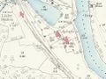
1883
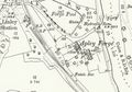
1902
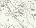
1927


See also
References
- ↑ 1.0 1.1 1.2 1.3 1.4 Marshall (1989) pp. 31-36,107.
- ↑ Vanns (1998) p. 49.
- ↑ Life Expectancy in years at various ages, by decade (Retrieved 1 May 2019)
- ↑ Nabarro (1971) p. 55.
- ↑ Mitchell and Smith (2007) fig. XIV.
Links
- Wikipedia: Thomas Charlton Whitmore
- Wikipedia: Apley Hall
| ||||||||||||||||||||