Difference between revisions of "Bower Yard Lime Kilns Siding"
(Add page on sidings (which I've never seen referenced elsewhere!)) |
m (Robin moved page Bowers Yard Lime Kilns Siding to Bower Yard Lime Kilns Siding: Rename as per discussion page) |
||
| (7 intermediate revisions by 2 users not shown) | |||
| Line 1: | Line 1: | ||
| − | + | [[File:OS_Bower_Yard_1927.jpg|thumb|300px|right|OS Map of 1927 showing Bower Yard siding (top left)]] | |
| + | '''Bower Yard Lime Kilns''' were located approximately ¼ mile upriver from [[Ironbridge and Broseley]] station, between that station and [[Buildwas]]. The kilns processed limestone into lime, rock having been quarried from the steep sided Ironbridge gorge at '''Benthall Edge'''. The quarries were busy in the 18th and 19th century, providing flux for use in the iron industry around Ironbridge and Coalbrookdale,<ref name="SevernGorge">[http://www.severngorge.org.uk/places-to-visit/ Bower Yard Limekiln], Severn Gorge Countryside Trust, accessed 16 July 2021</ref> but fell into disuse during the 1870s,<ref>[http://www.cbsconservation.co.uk/projects/bowers_yard_lime_kilns/ Bowers Yard Lime Kilns], CBS Conservation, accessed 7/12/2015</ref>. These original kilns may have been served by the railway<ref>[http://search.shropshirehistory.org.uk/collections/getrecord/CCS_MSA3885/ Shropshire's History], accessed 7/12/2015</ref> although OS maps show no evidence of a siding at this date. | ||
| − | The kilns were brought back into use during the 1920s<ref name="SevernGorge" /> | + | The kilns were brought back into use during the 1920s,<ref name="SevernGorge" /> with "1928" being inscribed in one of the kilns,<ref>[http://www.lynnemorgandesign.co.uk/portfolio.htm Lynne Morgan Design], portfolio showing information boards on the kilns, accessed 7/12/2015</ref> a rail siding being built at this time. Limestone from the quarries near the top of Benthall Edge was brought down to a terminal near the siding by a self-acting incline plane, from where it was moved to the kilns for burning. For some years, the GWR brought coal to the kilns and transported the lime to various areas of the country; they also used large quantities for cement in their own civil engineering operations.<ref Name="Beddoes"> SVR News 84, “For Broseley, see Ironbridge” (article by Keith Beddoes)</ref>. |
| − | == | + | The siding was still in existence in 1934,<ref>[[Bibliography#Books|Vanns (1998)]], photo dated 1934 on p.85 shows siding</ref> and it is not clear when the lime kilns and siding closed, although it is suggested that it could be as late as the 1960s.<ref>[http://www.severngorge.org.uk/wp-content/uploads/SGCT-Lime-Trail-Leaflet-final-v3.pdf Severn Gorge Country Trust Lime Trail Leaflet], accessed 7/12/2015</ref> |
| + | |||
| + | <gallery> | ||
| + | File:OS_Map_IronBridge.JPG | OS Map of Ironbridge and Bower Yard 1903 | ||
| + | </gallery> | ||
| + | |||
| + | Bower Yard can be seen in the OS Map of 1903 above, which pre-dates the 1920s siding. From around 1835 until 1897, the yard was the site of the ‘Bower Yard White Brickworks’. Clay was mined from Benthall Edge and brought to the works via a tramway and small incline plane over the railway, also visible on the map. The brickworks owners were also barge operators, exporting most of their products by river. The works became the ‘Benthall Firebrick Works’ in 1897, although mainly making glazed sanitary pipes by the 1920s. It then became the ‘Benthall Stoneware Company’ before World War 2, finally closing in 1955.<ref name = "Beddoes"/> | ||
| + | |||
| + | ==See also== | ||
| + | *[[Private sidings connected to the Severn Valley Railway]] | ||
| + | *[[Maps#Schematic maps of the pre-closure SVR | Pre-1963 map]] | ||
| + | *[[List of signal boxes#List of historical Signal Boxes and Ground Frames | List of historical Signal Boxes and Ground Frames]] | ||
| + | *[[Shropshire Historic Environment Record]] | ||
| + | |||
| + | ==References== | ||
<references /> | <references /> | ||
Revision as of 23:02, 16 July 2021

Bower Yard Lime Kilns were located approximately ¼ mile upriver from Ironbridge and Broseley station, between that station and Buildwas. The kilns processed limestone into lime, rock having been quarried from the steep sided Ironbridge gorge at Benthall Edge. The quarries were busy in the 18th and 19th century, providing flux for use in the iron industry around Ironbridge and Coalbrookdale,[1] but fell into disuse during the 1870s,[2]. These original kilns may have been served by the railway[3] although OSOrdnance Survey maps show no evidence of a siding at this date.
The kilns were brought back into use during the 1920s,[1] with "1928" being inscribed in one of the kilns,[4] a rail siding being built at this time. Limestone from the quarries near the top of Benthall Edge was brought down to a terminal near the siding by a self-acting incline plane, from where it was moved to the kilns for burning. For some years, the GWRGreat Western Railway brought coal to the kilns and transported the lime to various areas of the country; they also used large quantities for cement in their own civil engineering operations.[5].
The siding was still in existence in 1934,[6] and it is not clear when the lime kilns and siding closed, although it is suggested that it could be as late as the 1960s.[7]
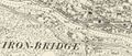
OSOrdnance Survey Map of Ironbridge and Bower Yard 1903

Bower Yard can be seen in the OSOrdnance Survey Map of 1903 above, which pre-dates the 1920s siding. From around 1835 until 1897, the yard was the site of the ‘Bower Yard White Brickworks’. Clay was mined from Benthall Edge and brought to the works via a tramway and small incline plane over the railway, also visible on the map. The brickworks owners were also barge operators, exporting most of their products by river. The works became the ‘Benthall Firebrick Works’ in 1897, although mainly making glazed sanitary pipes by the 1920s. It then became the ‘Benthall Stoneware Company’ before World War 2, finally closing in 1955.[5]
See also
- Private sidings connected to the Severn Valley Railway
- Pre-1963 map
- List of historical Signal Boxes and Ground Frames
- Shropshire Historic Environment Record
References
- ↑ 1.0 1.1 Bower Yard Limekiln, Severn Gorge Countryside Trust, accessed 16 July 2021
- ↑ Bowers Yard Lime Kilns, CBSCommunity Benefit Society, a charitable body Conservation, accessed 7/12/2015
- ↑ Shropshire's History, accessed 7/12/2015
- ↑ Lynne Morgan Design, portfolio showing information boards on the kilns, accessed 7/12/2015
- ↑ 5.0 5.1 SVRSevern Valley Railway News 84, “For Broseley, see Ironbridge” (article by Keith Beddoes)
- ↑ Vanns (1998), photo dated 1934 on p.85 shows siding
- ↑ Severn Gorge Country Trust Lime Trail Leaflet, accessed 7/12/2015