Difference between revisions of "Wilden Sand Siding"
(add link) |
m (add links) |
||
| Line 11: | Line 11: | ||
==See also== | ==See also== | ||
| − | [[List of signal boxes# List of historical Signal Boxes and Ground Frames| List of historical Signal Boxes and Ground Frames]] | + | *[[Private sidings connected to the Severn Valley Railway]] |
| − | [[H. Whitehouse's Sand Siding]] | + | *[[Maps#Schematic maps of the pre-closure SVR | Pre-1963 map]] |
| + | *[[List of signal boxes#List of historical Signal Boxes and Ground Frames | List of historical Signal Boxes and Ground Frames]] | ||
| + | *[[H. Whitehouse's Sand Siding]] | ||
==References== | ==References== | ||
<references/> | <references/> | ||
Revision as of 17:33, 30 November 2018
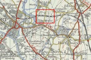
A sand quarry was located at Wilden, between Hartlebury and Stourport, served by a siding on the Severn Valley Railway.
Early history
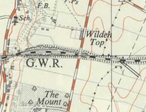
The Severn Valley Railway ran through a sandstone ridge at Wilden Top, around ¾ mile from Stourport. The railway could have passed through this via a tunnel as elsewhere on the line, but a large amount of spoil was required for a nearby embankment. As a result one of the largest cuttings on the line was constructed, around a third of a mile long and up to 60 ft deep. Unusually, a tunnel was first driven and laid with rails, then the ground above was dug away and dropped down shafts into wagons.[1]
Sand Quarry siding
A large sand quarry was situated north of the cutting. A ground frame, locked by the section token, controlled access to the siding. After the quarry closed, the siding was used to store coal wagons waiting to enter Stourport Power Station .[2]
See also
- Private sidings connected to the Severn Valley Railway
- Pre-1963 map
- List of historical Signal Boxes and Ground Frames
- H. Whitehouse's Sand Siding
References
- ↑ Marshall (1989) p. 41.
- ↑ Marshall (1989) p. 87.

