Difference between revisions of "Talk:Map"
| Line 12: | Line 12: | ||
I've labelled it as a schematic map, I'll still create an accurate geographic imagemap map as well, but I need a suitable map to base it on first.<br> | I've labelled it as a schematic map, I'll still create an accurate geographic imagemap map as well, but I need a suitable map to base it on first.<br> | ||
--[[User:Graham Phillips 110|Graham Phillips 110]] ([[User talk:Graham Phillips 110|talk]]) 12:52, 15 January 2015 (UTC) | --[[User:Graham Phillips 110|Graham Phillips 110]] ([[User talk:Graham Phillips 110|talk]]) 12:52, 15 January 2015 (UTC) | ||
| + | |||
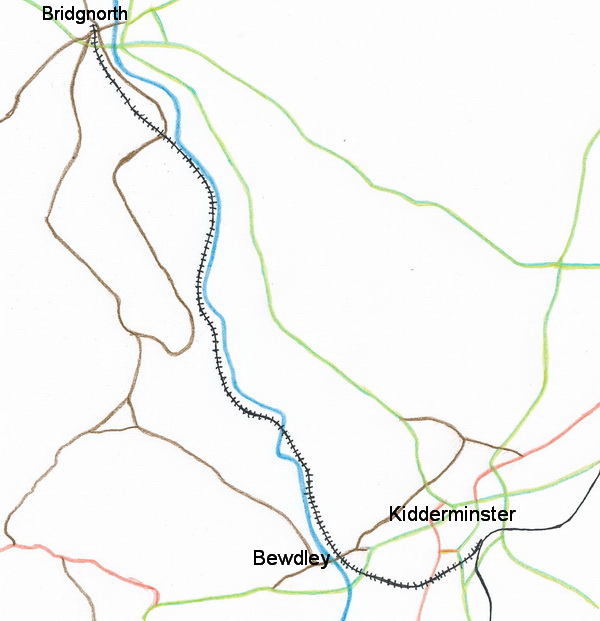
| + | Had a go at drawing the route of the Railway to scale, copied from a map. 3 major towns shown, also river, railway & most roads (but not the country lanes) | ||
| + | |||
| + | [[File:Svr-line.jpg]] | ||
| + | |||
| + | It's far from perfect but is less overpowering than copying a map with too much detail on. Is it worth trying to develop it further by adding smaller villages & marking the stations? [[User:Sharpo|Sharpo]] ([[User talk:Sharpo|talk]]) 22:47, 15 January 2015 (UTC) | ||
Revision as of 22:47, 15 January 2015
The route of the Railway with links looks good & works very well. Sharpo (talk) 10:08, 15 January 2015 (UTC)
I gave up on the template idea, that's just a table with embedded images and links, which ends up looking and behaving the same.
At the moment, I can show the table with no borders, or I a can align it to the right, but not both at the same time.
For some reason, aligning it to the right puts a 1 pixel border round every cell, which shows up as breaks in the red line.
--Graham Phillips 110 (talk) 10:14, 15 January 2015 (UTC)
A "straight" diagram of the SVRSevern Valley Railway is always confusing, I think, as it is really a "U" shaped route. Gives the impression the mainline connection goes to the left at Kidder. I suppose the diagram could be made the shape of a reverse "J" but that might not fit the page so well, or may be more complicated? Just a suggestion! Sharpo (talk) 11:01, 15 January 2015 (UTC)
If at first you don't succeed, cheat.
It is now a 1x1 table with all the icons and links in the single cell, separated by line breaks. It seems to work.
I've labelled it as a schematic map, I'll still create an accurate geographic imagemap map as well, but I need a suitable map to base it on first.
--Graham Phillips 110 (talk) 12:52, 15 January 2015 (UTC)
Had a go at drawing the route of the Railway to scale, copied from a map. 3 major towns shown, also river, railway & most roads (but not the country lanes)
It's far from perfect but is less overpowering than copying a map with too much detail on. Is it worth trying to develop it further by adding smaller villages & marking the stations? Sharpo (talk) 22:47, 15 January 2015 (UTC)
