Gradient profile and mileages
The gradient profile of the SVR between Kidderminster and Bridgnorth is shown below. The diagram, which is reproduced from the SVR Visitor Guide Eighth Edition (2001), is based on official GWR documents.

GWR practice was to measure distances to particular locations from London Paddington via the most direct GWR route. In the SVR gradient profile, mileages between Kidderminster and Bewdley are measured from London Paddington via Birmingham Snow Hill, while mileages between Bewdley and Bridgnorth are measured from London Paddington via Oxford, Evesham and Worcester. This accounts for the change in mileage at Bewdley South Junction from 138 miles 21 chains to 137 miles 12 chains (one chain is equal to 22 yards or 1/80th of a mile).
The number shown is the gradient in each section (the vertical scale is exaggerated), thus on leaving Kidderminster the line initially goes downhill with a gradient of 1 in 112. ‘L’ indicates level.
Mileage posts showing the distance from London Paddington, as measured above, can be seen at the lineside. In the first example shown, the distance just south of Arley Station is 140¾ miles (the vertical bars below the number show the number of quarter miles). One mileage post is situated at the foot of Highley Signal Box, showing that it is exactly 143¼ miles from Paddington.
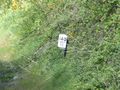
Mile post near Arley
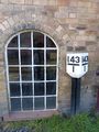
Mile post at Highley Signal box


Gradient posts showing changes in gradient can also be seen at the lineside. The design varies, but generaly follows the principle of this prominent example near Highley station.
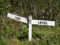
Gradient post
