File:Woofferton station (disused) - geograph.org.uk - 316919.jpg
Jump to navigation
Jump to search


No higher resolution available.
Woofferton_station_(disused)_-_geograph.org.uk_-_316919.jpg (640 × 480 pixels, file size: 102 KB, MIME type: image/jpeg)
Summary
| Description |
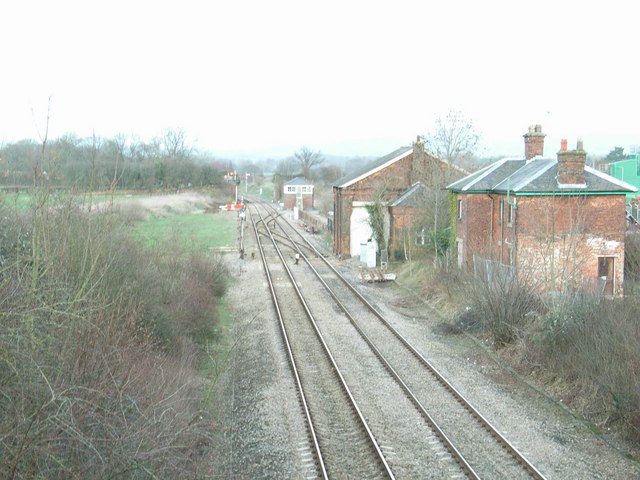
English: Woofferton station (disused) The site of the former station at Woofferton. The posts that once held the station nameboard still stand, just to the right. The next building after the station buildings was formerly the goods shed.
Woofferton was a junction station, with a branch line running to Bewdley, via Tenbury Wells. This line diverged to the right from the current, main line just after the station. |
| Date | |
| Source | From geograph.org.uk |
| Author | David Luther Thomas |
| Attribution (required by the license) | David Luther Thomas / Woofferton station (disused) / |
| Camera location | | View this and other nearby images on: OpenStreetMap |
|---|
_-_geograph.org.uk_-_316919.jpg¶ms=052.310060_N_-002.715100_E_globe:Earth_type:camera_source:geograph-osgb36(SO51346823)_heading:45.00&language=en)
| Object location | | View this and other nearby images on: OpenStreetMap |
|---|
_-_geograph.org.uk_-_316919.jpg¶ms=052.310780_N_-002.714200_E_globe:Earth_class:object_type:object_source:geograph-osgb36(SO51406831)_heading:45.00&language=en)
Licensing

|
This image was taken from the Geograph project collection. See this photograph's page on the Geograph website for the photographer's contact details. The copyright on this image is owned by David Luther Thomas and is licensed for reuse under the Creative Commons Attribution-ShareAlike 2.0 license.
|
This file is licensed under the Creative Commons Attribution-Share Alike 2.0 Generic license.
Attribution:
David Luther Thomas
- You are free:
- to share – to copy, distribute and transmit the work
- to remix – to adapt the work
- Under the following conditions:
- attribution – You must give appropriate credit, provide a link to the license, and indicate if changes were made. You may do so in any reasonable manner, but not in any way that suggests the licensor endorses you or your use.
- share alike – If you remix, transform, or build upon the material, you must distribute your contributions under the same or compatible license as the original.
File history
Click on a date/time to view the file as it appeared at that time.
| Date/Time | Thumbnail | Dimensions | User | Comment | |
|---|---|---|---|---|---|
| current | 16:16, 30 December 2010 | | 640 × 480 (102 KB) | wikimediacommons>GeographBot | == {{int:filedesc}} == {{Information |description={{en|1=Woofferton station (disused) The site of the former station at Woofferton. The posts that once held the station nameboard still stand, just to the right. The next building after the station building |
File usage
The following page uses this file:
_-_geograph.org.uk_-_316919.jpg)