Stourport


| Towards Hartlebury | Towards Shrewsbury |
|---|---|
| Hartlebury (3 miles) | Bewdley (2½ miles) via Burlish Halt (from 1930) |
Stourport Station
Stourport Station was located 3 miles from Hartlebury and 37¾ miles from Shrewsbury. It was considered one of the principal stations on the line, with two platforms and a passing loop from opening in 1862 as well as a small goods yard and goods shed. The station building was almost identical to those at Bewdley and Buildwas. The location of the station just a short way north of the town made it perhaps the most convenient of the Severn Valley Railway’s stations relative to the town it served.
Stourport station was officially renamed 'Stourport-on-Severn' in 1934, possibly to avoid confusion with nearby Stourbridge.
The Shropshire & Worcestershire Electric Power Co built a power station at Stourport after the First World War. However a direct rail connection to the Severn Valley Railway was only opened in 1940, coal deliveries before then being mainly via the River Severn or the Staffordshire & Worcestershire Canal. Once opened, the rail connection remained until January 1981, prolonging the life of the southern end of the Severn Valley Railway.
The extract from Ordnance Survey Map SO87, surveyed 1938 - 1949, published 1951, shows the branch line between Stourport Power Station (bottom) and Stourport Station (marked ‘Sta’). The line continues northwards towards Burlish Halt (top).
The area formerly occupied by the station is now part of a housing estate.
The town of Stourport
The origins of the Worcestershire town of Stourport date back to the completion of the Staffordshire & Worcestershire Canal in 1771. In that year John Wesley described Stourport as a "well-built village", but following the opening of the canal for trade in 1772 the village quickly grew into a town based around the large canal basins that served as the ‘port’, reaching a population of 1,300 by 1795.[1]
The early growth of Stourport saw a corresponding decline in the fortunes of Bewdley as a port.[2] However further significant growth of Stourport was effectively ended by the opening of the Worcester and Birmingham Canal in 1816. This provided a direct link between the two towns.
Gallery
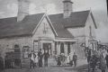
Stourport Station in 1910
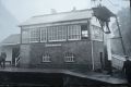
Stourport signal box in 1968


See also
The Severn Valley Railway under GWR/BR ownership
References
The Severn Valley Railway, John Marshall
Severn Valley Railway, A View from the Past, MA Vanns