Difference between revisions of "National Cycle Route 45"
m (picture format) |
(additional info and history) |
||
| (8 intermediate revisions by 2 users not shown) | |||
| Line 1: | Line 1: | ||
[[File: Route_45_20150528.jpg|thumb|200px|right| National Cycle Route 45]] | [[File: Route_45_20150528.jpg|thumb|200px|right| National Cycle Route 45]] | ||
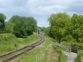
| − | National Cycle Route 45 | + | Part of the 270 mile '''National Cycle Route 45''' follows the [[Severn Valley]] between the Ironbridge Gorge and Bewdley, utilising the former trackbed and crossing the present day railway twice. |
| − | The Cycle Route | + | The Cycle Route crosses from the east bank of the [[River Severn]] to the west bank via Abraham Darby’s bridge at Ironbridge. From the site of the former [[Ironbridge|Ironbridge station]], now the main town car park, it then closely follows the disused trackbed southwards via [[Jackfield Halt]], [[Coalport]] and [[Linley]] to the edge of Bridgnorth Golf Club. From there the Route follows roads through the town, continuing up Hollybush Road where it passes under the footbridge outside [[Bridgnorth|Bridgnorth Station]] and crosses the former line between the station and [[Bridgnorth Tunnel]]. |
| − | There are a number of farm crossings between Hampton Loade and Country Park which also cross the Cycle Route. | + | South of Bridgnorth, the Route then follows the road through the villages of Eardington and Chelmarsh, returning to cross the railway at the [[Underbridge at Hampton Loade]]. It then follows the present day railway closely from [[Hampton Loade | Hampton Loade Station]] towards [[Country Park Halt]]. |
| + | |||
| + | This part of the Cycle Route was built by Shropshire County Council in [[Severn Valley Railway Timeline 2000-2009#2003 | 2003]]. The SVR was initially opposed to its construction as it would be on the SVR’s land and in close proximity to the line. However agreement was reached after considerable discussion with the Council, and today the route is popular with both cyclists and walkers. | ||
| + | |||
| + | The Cycle Route leaves the SVR a short distance before the Halt, turning away into the main area of the Country Park. However a footpath continues to the Halt itself. After passing through the Country Park, Route 45 crosses the railway again at [[Arley Station Bridge]], then enters the [[Wyre Forest]], where it follows the trackbed of the [[Wyre Forest Line]] towards [[Bewdley]]. Although no longer following the railway, the Cycle Route continues through [[Stourport]] and [[Hartlebury]]. | ||
| + | |||
| + | There are a number of [[List of infrastructure | farm crossings]] between Hampton Loade and Country Park which also cross the Cycle Route. | ||
| + | |||
| + | <gallery> | ||
| + | File: Crossing_13_20150528.jpg | Hampton Loade Station seen from the Cycle Route (right) | ||
| + | File:Mercian Way 20090817.jpg | This Mercian Way marker overlooks the railway | ||
| + | File:Cycle path through Wyre Forest - geograph.org.uk - 1149603.jpg | Road overbridge in the Wyre Forest | ||
| + | </gallery> | ||
==See also== | ==See also== | ||
| + | [[From The Window]]<br> | ||
[[Hampton Loade | Hampton Loade Station]]<br> | [[Hampton Loade | Hampton Loade Station]]<br> | ||
[[Country Park Halt]]<br> | [[Country Park Halt]]<br> | ||
| − | [[ | + | [[Farm crossing north of milepost 145]]<br> |
| + | [[Farm crossing near milepost 145]] | ||
| + | |||
| + | ==Links== | ||
| + | [https://www.sustrans.org.uk/find-a-route-on-the-national-cycle-network/route-45/ Route 45 on the Sustrans web site] | ||
Revision as of 16:17, 26 February 2020

Part of the 270 mile National Cycle Route 45 follows the Severn Valley between the Ironbridge Gorge and Bewdley, utilising the former trackbed and crossing the present day railway twice.
The Cycle Route crosses from the east bank of the River Severn to the west bank via Abraham Darby’s bridge at Ironbridge. From the site of the former Ironbridge station, now the main town car park, it then closely follows the disused trackbed southwards via Jackfield Halt, Coalport and Linley to the edge of Bridgnorth Golf Club. From there the Route follows roads through the town, continuing up Hollybush Road where it passes under the footbridge outside Bridgnorth Station and crosses the former line between the station and Bridgnorth Tunnel.
South of Bridgnorth, the Route then follows the road through the villages of Eardington and Chelmarsh, returning to cross the railway at the Underbridge at Hampton Loade. It then follows the present day railway closely from Hampton Loade Station towards Country Park Halt.
This part of the Cycle Route was built by Shropshire County Council in 2003. The SVRSevern Valley Railway was initially opposed to its construction as it would be on the SVRSevern Valley Railway’s land and in close proximity to the line. However agreement was reached after considerable discussion with the Council, and today the route is popular with both cyclists and walkers.
The Cycle Route leaves the SVRSevern Valley Railway a short distance before the Halt, turning away into the main area of the Country Park. However a footpath continues to the Halt itself. After passing through the Country Park, Route 45 crosses the railway again at Arley Station Bridge, then enters the Wyre Forest, where it follows the trackbed of the Wyre Forest Line towards Bewdley. Although no longer following the railway, the Cycle Route continues through Stourport and Hartlebury.
There are a number of farm crossings between Hampton Loade and Country Park which also cross the Cycle Route.
Hampton Loade Station seen from the Cycle Route (right)
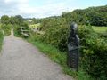
This Mercian Way marker overlooks the railway
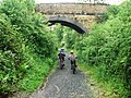
Road overbridge in the Wyre Forest


See also
From The Window
Hampton Loade Station
Country Park Halt
Farm crossing north of milepost 145
Farm crossing near milepost 145