Country Lorry Service and Cartage Service
As well as transporting goods between stations by rail, the GWR was also able to collect & deliver goods and parcels to and from local addresses via the Country Lorry Service, Cartage Service or independent carrier.
Contents
Cartage services
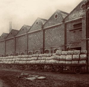
In its earliest days the GWR was principally focussed on passenger traffic, using third-party contractors and carriers (later referred to as cartage agents) such as Thomas Bantock to handle its goods cartage work. Cartage agents were responsible for providing their own horse-drawn or motor vehicles and were required to describe themselves as an Agent for business purposes. They were therefore sometimes wrongly referred to as 'Goods Agents' although the latter term more correctly referred to the local manager of goods traffic on the railway itself.[1]
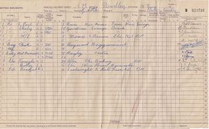
Towards the end of the 19th century the GWR began to expand its own cartage fleet, often purchasing the vehicles from the cartage agents. In 1878 the GWR acquired a number of horse-drawn vehicles from Thomas Bantock including 2 drays at Bewdley, 6 drays at Kidderminster, and two drays and a covered van at Stourport.[2]
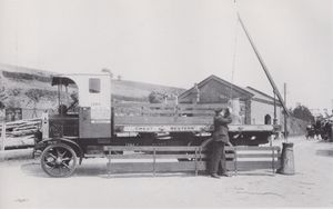
At the start of the 20th Century horse drawn traffic still predominated. In 1905 the GWR had just 8 goods motor vehicles in use compared with more than 3,000 horses. The earliest GWR motor vehicles were serviced and maintained by their own drivers, but by 1909 a separate GWR 'Road Motor Car Department' had been formed.[3] After the First World War the GWR increasingly dispensed with the services of cartage agents, using its own motor vehicles including the Country Lorry Service.
Country Lorry Service
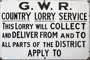
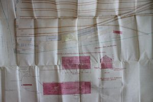
The GWR introduced the Country Lorry Service after the First World War. This allowed agricultural and other goods to be transported beyond the railway companies' normal collection and delivery radius, which was usually limited to urban areas and their immediate fringes.[4] The first nine services had been established by 1925; thereafter the number increased rapidly with the earliest on the Severn Valley Branch being at Bewdley in 1927, with a new 20 ton weighbridge being provided the same year[5], and Bridgnorth in 1928.[6] GWR plans from 1928 show a new garage with a maintenance pit and outside wash area being proposed at Kidderminster as 'cartage accommodation'.
Until 1928, railway companies were only allowed to carry goods which had been, or were to be, carried by rail. The 1928 Road Act removed this restriction; thereafter railway companies began to offer "throughout road" services (ie not involving any rail transport). After that time the number of Station Truck workings for small consignments reduced, while the Country Lorry Service saw a further expansion. In 1930 there were some 160 "Tranship Sheds" operating across the GWR, where goods were transferred between wagons for onward shipment; by 1932 rationalisation of this system had reduced the number to just nine.[7]
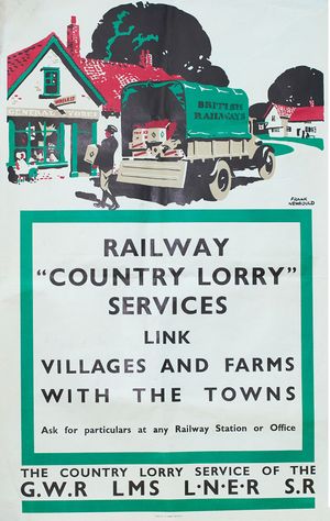
In 1937 the GWR collection and delivery services utilised some 2,200 motor vans and lorries, although there were still some 3,000 horse-drawn wagons and carts, and 1,600 horses in use.[8] In 1938 the GWR Road Transport Department built a Repair Shop in Kidderminster Yard.[9] At the outbreak of World War Two the GWR had 184 Country Lorry services in operation. The other 'Big 4' railway companies had introduced similar services, reflected in posters such as that shown above.
After the Second World War the GWR began to move to a 'zonal' distribution system, with Bewdley no longer having a Country Lorry service by 1946.[10]
A 1938 GWR publication, 'Towns villages, outlying works etc. served by the Great Western Railway' gives a list of all such places, their distance from the local station and the method of delivery. Those on the Severn Valley Branch and Tenbury Branch are shown below. Places marked with an asterisk are within the company's free cartage boundary, with "(partly)" indicating it was not entirely within that boundary. In all other cases there would be a charge for collection or delivery in addition to the normal station to station charge.
Where a station is not listed (e.g. Hampton Loade), no collection or delivery service was available, although some smaller stations were covered by services from nearby larger stations (e.g. Linley and Eardington from Bridgnorth).
Cartage charges in 1926
The following rates of charges were given in an article on 'Cartage of Farm Traffic at Country Stations' in the October 1926 issue of the Great Western Railway Magazine.
(Rates are given in pre-decimal currency. 2s 6d = 12.5p and 10s 6d = 52.5p)
| Distance from station | 4 ton loads per ton |
2 ton loads per ton |
| Up to 2 miles | 2s 6d | 3s |
| Up to 3 miles | 2s 6d | 4s |
| Up to 5 miles | 3s 6d | 5s 6d |
| Up to 7 miles | 5s | 7s |
| Up to 9 miles | 6s 6d | 8s 6d |
| Up to 12 miles | 8s | 10s 6d |
Lorry Services and Cartage Services on the SVR
Kidderminster
- Cartage Service:
Kidderminster*, Baldwins Ltd. Stour Vale Iron Works* 1¼ miles, Broadwaters (parcels)* (partly) 1¾ miles, Blakebrook* 1½ miles, Clensmore Wharf* 1 mile, Comberton* (partly) ½ mile, Foley Park* 1½ miles, Franche*(partly) 3 miles, Greenhill* 1½ miles, Hoobrook* (partly) 1 mile, Hurcott* (partly) 1½ miles, Old Wharf ¾ mile
- Lorry Service:
Alveley 7 miles, Attwood Park 4½ miles, Blakedown 4 miles, Blakesall 4 miles, Broadwaters (goods)* (partly) 1¾ miles, Brockencote 4 miles, Dunclent 2 miles, Franche* (partly) 3 miles, Habberley 2½ miles, Harvington 3 miles, Hoobrook 1 mile, Summerfield 3 miles, Horseley Hills 4½ miles, Kingsford 4½ miles, Lea Castle 3 miles, Little Hoboro' 4½ miles, Low Habberley 2½ miles, Low Hill 2 miles, Park Attwood 4½ miles, Romsley 7 miles, Shatterford 5 miles, Shenstone 2¾ miles, Stone 2 miles, Shenstone 2½ miles, Trimpley 3½ miles, Wolverley (goods) 2½ miles
- Lorry Service (Midland Red Motor Services):
Bluntington 5 miles, Caunsall 4 miles, Chaddesley Corbett 4 miles, Cookley 3 miles, Corbett & Sons Saw Mills, (Chaddesley) 4 miles, Franche (partly) 3 miles, Wolverley (parcels) 2½ miles
Hartlebury
- Cartage Service:
Hartlebury*
- Lorry Service:
Acton 3 miles, Bishops Wood 2 miles, Boreley 5 miles, Bradford 3 miles Brockencote 3½ miles, Brookhampton 3½ miles, Cakebole 2½ miles, Chadwick 2½ miles, Charlton 1½ miles, Clareland 2½ miles, Comhampton 3 miles, Crossway Green 2 miles, Cutnall Green 3 miles, Doverdale 3 Miles, Dunhampton 3½ miles, Elmbridge 4 miles, Elmley Lovett 2 miles, Holt Fleet 5 miles, Lincomb 2½ miles, Line Holt 3 miles, Oakhampton 4 miles, Ombersley 5 miles, Rushock 3½ miles, Shenstone 2 miles, Stone 3 miles, Summerfield 2 miles, Sytchampton 3 miles, Titton 2 miles, Torton 1½ miles, Uphampton 4½ miles, Whitlenge 1 mile
Stourport
- Cartage Service:
Stourport*, Wilden Iron Works (Baldwins Ltd.)* (Goods only) 1½ miles
- Lorry Service:
Abberley 5 miles, Areley Kings 1½ miles, Astley 3½ miles, Astley Cross 2 miles, Dunley 2½ miles, Great Witley 5½ miles, Heightington 5 miles, Lincomb 3 miles Little Witley 7 miles, Shrawley 4½ miles, Stockton-on-Teme 10 miles, Wilden 1½ miles
- Lorry Service, Omnibus:
Netherton 5 miles, Woodbury Hill 7 miles
- For delivery by barge:
Baldwins Ltd. Stour Vale Iron Works* 4½ miles
Bewdley
- Cartage Service:
Bewdley ½ mile
- Lorry Service:
Blackstone 1½ miles, Button Oak 3 miles, Dowles 1½ miles, Far Forest 5 miles, Heightington 6 miles, Kinlet 5 miles, Lye Head 3 miles, Pound Green 4 miles, Ribbesford 1½ miles, Rock 6 miles, Shatterford 5 miles, Trimpley 3 miles
Highley
- Carrier:
Highley ½ mile
Bridgnorth
- Cartage Service:
Bridgnorth*, Oldbury (Parcels)
- Lorry Service:
Ackleton 5 miles, Acton Round 5 miles, Aldenham Park 3 miles, Alveley 6 miles, Apley Park 5 miles, Artlebury 3 miles, Aston 6 miles, Aston Eyres 4 miles, Barnsley 4 miles, Bentley 1½ miles, Beobridge 5 miles Billingsley 6 miles, Broughton 6 miles, Chelmarsh 4 miles, Chesterton 6 miles, Chetton 3½ miles, Claverley 6 miles, Cleobury North 9 miles (Truck loads), Colmore Green 4 miles, Coton 5½ miles, Criddon 4 miles, Dallicot 4 miles, Ditton Priors (Truck loads), Deuxhill 5 miles, Eardington 2 miles[Notes 1], Endness 3 miles, Ewden Burnell 4 miles, Ewden George 4 miles, Eyres Aston 4 miles, Faintree 4½ miles, Farmcote 5 miles, Glazeley 4 miles, Heathton 7 miles, Hilton 4½ miles, Hopstone 5½ miles, Linley 5 miles, Ludstone (goods) 7 miles, Monk Hopton 6 miles, Morville 3 miles, Middleton Scriven 5 miles, Netchworth (goods) 5 miles, Newton 3 miles, Nordley 3½ miles, Nordley Regis 4 miles, Norton(Nr. Shifnal) 5 miles, Oldbury (Goods), Patmarsh 3 miles, Rudge 7 miles, Rudge Heath 8 miles, Shipley (goods) 6 miles, Sidbury 6 miles, Stockton 7 miles (goods), Tasley 2 miles, The Down 3 miles, Tuckhill 6 miles, Upton Cressett 5 miles, Winscott 2 miles, Woodside 2 miles, Woundale 4 miles
- Lorry Service (Carrier):
Allscot 2 miles, Astley Abbots 2½ miles, Bradney 3 miles Bromley 2 miles, Catstree 3 miles, Cranmere 4 miles, Danesford 1 mile, Ewdness 3 miles, Netchworth (parcels) 5 miles, Quatford 2 miles, Quatt 4 miles, Rindleford 3 miles, Roughton 3 miles, Shipley (parcels) 6 miles, Six Ashes 6 miles, Stapleford 5 miles, Stockton 7 miles (parcels), Swancott 1½ miles, Worfield 4 miles, Wyken 3 miles
Coalport
- Railway Porter:
Coalport*
Ironbridge
- Cartage Service:
Barrow* (partly) 3½ miles, Benthall* 1 mile, Broseley* 1 mile, Broseley Wood* ½ mile, Ironbridge*, Jackfield* 1 mile, Ladywood* ¼ mile, Linley Green* (partly) 3½ miles, Madeley Wood* 1 mile, Posenhall* (partly) 2½ miles, Willey* (partly) 3½ miles, Wyke* (partly) 2½ miles
Maw & Co.
- Siding
- Cartage Service* 1½ miles
Buildwas
- Lorry Service:
Buildwas, Leighton 2½ miles, Farley 2 miles, Tickwood Hall 2¼ miles, Wyke 3 miles
- Railway Porter:
Buildwas* (partly)
Ironbridge Power Station
- Siding (goods only)
- Railway Porter* (parcels only) ¼ mile
Cressage
- Lorry Service:
Cressage ¼ mile, Dryton 3 miles, Eaton Constantine 1½ miles, Eyton-on-Severn 3 miles, Garmston 2½ miles, Harley 2 miles, Kenley 4 miles, Leighton 2½ miles, Shineton or Sheinton 2 miles
Berrington
- Lorry Service:
Abbots Betton 2 miles, Acton Burnell 3 miles, Acton Piggott 3 miles, Atcham 1 mile, Attingham 1½ miles, Berrington* ½ mile, Berwick Wharf 3 miles, Betton 1 mile, Betton Abbotts 2 miles, Betton Strange 3 miles, Boreton 2 miles, Boreton Grange* 2 miles, Brompton* 1 mile Cantlop 2 miles, Charlton Hill 4 miles, Chilton 1 mile, Cound 2 miles, Cound Moor 4 miles, Cronk Hill* ¾ mile, Cross Houses* ¼ mile, Dinchope* 1 mile, Eaton Mascott 1½ miles, Emstrey 2½ miles, Frodesley 4 miles, Golding 3 miles, Harnage 3 miles, Langley* 5 miles, Longner 3 miles, Lower Cound* 1 mile, Norton 2 miles, Pitchford 2½ miles, Ruckley 5 miles, Smethcote 2½ miles, Uckington 4 miles, Upper Cound 2 miles, Uppington 4 miles, Wroxeter 3 miles
Lorry Services and Cartage Services on the Tenbury Branch
The Country Lorry Service at Tenbury started on February 1 1931[11].
Cleobury Mortimer
- Cartage Service:
Cleobury Mortimer 2¼ miles
- Lorry Service:
Cleobury North 10 miles (Less than truck loads), Chilton 4 miles, Ditton Priors (Less than truck loads, and all traffic for R.N. Armaments Depot), Farlow 2 miles, Old Storridge 8 miles, Prescot 7 miles, Stottesden 8 miles, Wheathill 9 miles
Newnham Bridge
- Lorry Service:
Eardiston 3½ miles, Great Witley 7½ miles, Hanley Child 4 miles, Knighton-upon-Teme 1 mile, Lindridge 2 miles, Mamble 3 miles, Milson 3 miles, Neen Sollars 6 miles, Orleton 4 miles, Pensax 6 miles, Rochford 4 miles, Rochford Mount 4 miles, Stockton-on-Teme 5 miles, Upper Rochford 4 miles
- Railway Porter:
Newnham Bridge* (Within ½ mile of station)
Tenbury Wells
- Cartage Service:
Greenway Head 1 mile, Tenbury Wells*
- Lorry Service:
Aston Bank 3 miles, Berrington Heath 2 miles, Bockleton 5 miles, Boraston 2 miles, Broadheath 5 miles, Burford 1 mile, Coreley 4½ miles, Dean Park ½ mile, Eardiston 7 miles, Great Kyre 4 miles, Greet(Greete on modern maps) 2 miles, Hanley Child 6 miles, Harpfields 2 miles, Hartall 2 miles, Hopton wafers 6 miles, Knighton-upon-Teme 1 mile, Kyre Magna 4 miles, Kyrewood 2 miles, Leysters 4½ miles, Little Kyre 4 miles, Lower Hanley 5 miles, Magna Kyre 4 miles, Middleton 4 miles, Miles Hope 2½ miles, Nash 2½ miles, Neen Sollars 5 miles, Old wood Common 2 miles, Rochford 3 miles, Rochford Mount 3½ miles, Rosedale 5 miles, St. Michaels 1½ miles, Stanford 7 miles, Stanford Bridge 7 miles, Stanford-on-Teme 7 miles, Stoke 4 miles, Stoke Bliss 6½ miles, St. Michaels 1½ miles, Sutton 2½ miles, Weston 3 miles, Whitton 3½ miles,
Easton Court
- Lorry Service:
Berrington Green 1 mile, Easton Court, Little Hereford ½ mile,
Woofferton
- Lorry Service:
Ashford Carbonell 2½ miles, Brimfield ½ mile, Woofferton
See also
Notes
- ↑ Eardington village is ¾ from Eardington Station with no local cartage service.
References
- ↑ Atkins (2019) p.64.
- ↑ Atkins (2019) pp.67-69.
- ↑ Atkins (2019) pp 6-8.
- ↑ Atkins & Hyde (2000) p14.
- ↑ Great Western Railway Magazine, June 1927
- ↑ Atkins (2019) pp.79-80.
- ↑ Atkins & Hyde (2000) p16.
- ↑ Atkins & Hyde (2000) p22.
- ↑ Atkins (2019) p26.
- ↑ Atkins (2019) p.82.
- ↑ Advert from the Kington Times on the British Newspaper Archive
