Accommodation bridge near Severn Lodge

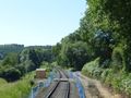
Bridge 19 is an accommodation underbridge allowing access from Severn Lodge Farm to the south end of a large field next to the River Severn. A public footpath also runs under the bridge via a stile. The photograph shows the view from the Severn Lodge side looking East, with the River Severn seen beneath the bridge and Bromley Farm on the opposite hilltop. Bridge 20 allows access to the same field.
County Boundary
Bridge 19 is situated close to the border between Worcestershire (Wyre Forest) and Shropshire, and the area is therefore also known as "County Boundary". Travelling north, it is the first bridge not to appear on the Wyre Forest District Council Local Heritage List. Examination of Ordnance Survey maps places it around 100 yards within Shropshire.
'Worcestershire' and 'Shropshire' county boundary boards were erected by the SVRSevern Valley Railway some years ago, both of which are visible from passing trains. The former is in approximately the correct position, but the latter was positioned north of Bridge 19, creating an apparent 'no man's land' between the two boards. This was done to improve visibility.[1]
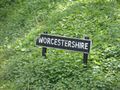
Worcestershire boundary marker
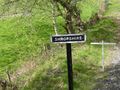
Shropshire boundary marker


County Boundary Slip
In June 2017 the SVRSevern Valley Railway announced problems with an embankment slippage immediately north of Bridge 19, evidence of which had first been detected in 2016 as a series of track "twist" faults.
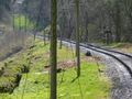
A view of the slip area in April 2017

During June 2017 the design for the remedial work required to stabilise the area was completed and work started to prepare the site for the stabilisation scheme.[2][3] The presence of an underground oil pipeline which runs beneath Bridge 19 prevented the heavy equipment required from accessing the slip area, requiring the SVRSevern Valley Railway to install a temporary crossing at the site.
Bridge 19 (left) and the slip area June 2016
Crossing installed to provide access to the slip area


The stabilisation scheme principally involves 'soil nailing', a process used successfully elsewhere along the line after the storm damage of 2007. Steel rods are driven or bored through the slip into the solid bedrock beneath and secured in place with a concrete grout.[4] The photograph below shows this work in progress in July 2017. Around 500 of these 'nails' will be required, as well as significant improvements to drainage in the area.[2]
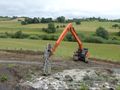
Soil nailing in progress, July 2017.

The SVRSevern Valley Railway anticipates completing the repairs by October 2017.[2]
See also
Towards Kidderminster
List of infrastructure
Towards Bridgnorth
References
- ↑ Article in SVRSevern Valley Railway News
- ↑ 2.0 2.1 2.2 County Boundary Slip 2017 on SVRLive
- ↑ SVRSevern Valley Railway News 198
- ↑ Sowden (2012) p. 12.