File:Hartlebury Railway Station - geograph.org.uk - 883215.jpg
From SVR Wiki

Size of this preview: 800 × 505 pixels. Other resolutions: 320 × 202 pixels | 1,024 × 647 pixels.
Original file (1,024 × 647 pixels, file size: 175 KB, MIME type: image/jpeg)
Summary
| Description |
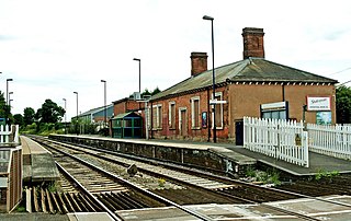
English: Hartlebury Railway Station On the Worcester-Kidderminster-Birmingham line this station isn't used as much as it could be because a lot of trains don't stop here. As a result the station is unstaffed and the original station buildings are no longer used for passengers. Instead the two platforms each have a bus shelter type structure for passengers to wait in. The original station building on the right in this view is now used as industrial premises. |
| Date | |
| Source | From geograph.org.uk |
| Author | P L Chadwick |
| Attribution (required by the licence) | P L Chadwick / Hartlebury Railway Station / |
| Camera location | | View this and other nearby images on: OpenStreetMap |
|---|
_heading:202.00&language=en-gb)
| Object location | | View this and other nearby images on: OpenStreetMap |
|---|
_heading:202.00&language=en-gb)
Licensing

|
This image was taken from the Geograph project collection. See this photograph's page on the Geograph website for the photographer's contact details. The copyright on this image is owned by P L Chadwick and is licensed for reuse under the Creative Commons Attribution-ShareAlike 2.0 license.
|
This file is licensed under the Creative Commons Attribution-Share Alike 2.0 Generic licence.
Attribution: P L Chadwick
- You are free:
- to share – to copy, distribute and transmit the work
- to remix – to adapt the work
- Under the following conditions:
- attribution – You must give appropriate credit, provide a link to the licence, and indicate if changes were made. You may do so in any reasonable manner, but not in any way that suggests the licensor endorses you or your use.
- share alike – If you remix, transform, or build upon the material, you must distribute your contributions under the same or compatible licence as the original.
File history
Click on a date/time to view the file as it appeared at that time.
| Date/Time | Thumbnail | Dimensions | User | Comment | |
|---|---|---|---|---|---|
| current | 20:49, 31 August 2017 | | 1,024 × 647 (175 KB) | Geograph Update Bot | Higher-resolution version from Geograph. |
File usage
The following 2 pages link to this file: